MAP OF POMERANIA, JB Homann, copperplate engraving, circa 1730

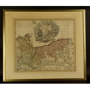
Map of the Duchy of Pomerania.

Nuremberg, circa 1730

Johann Baptist Homann (1664-1724) - a respected German cartographer, engraver, publisher of maps and globes. In 1702 he founded a cartographic publishing house in Nuremberg. In the years 1707, 1712 and 1716 he published more atlases, extended with more and more maps. His son Johann Christoph helped him in the publishing house, which he did also after his father's death.

More details


1 900 zł tax incl.

Colored copperplate.

Dim. total: 78 x 67 cm. Dim. of the map itself: 56 x 49 cm.

Map of the Duchy of Pomerania and adjacent areas, as evidenced by the cartouche placed on the map. The cartouche is in the form of a cloud on which characters of various origins, including mythological ones, are placed. The inscription was placed on a drapery supported by putti. At the very end, there is information about the imperial privilege received in 1729 by the Homanna publishing house.